HUNAGI Napló legutóbbi látogatói

Címkék

#SDG11 14. ICGC 2030 Agenda 20th ISDE 3D 3D city modelling 3D city models 3D SIG 4-es metró 5. Digital Earth Summit 5. Térinformatikai Konferencia és Szakkiállítás 6th Digital Earth Summit 7 ICC&GIS adatpolitika Afrika Expo és Vásár Agenda 2030 AGEO AGILE AGILE 2014 Agile 2015 AGILE 2017 AGIT AGIT Expo Agrárinformatika Agriculture AgriFuture Appathon ARSET ASGC Atlas Human Planet 2018 Award Bernhard Harzer Verlag Best Practice BiDS 14 Big Data Big Data from Space Big Spatial Data BIM biodiversity BKK BME BME ÁGT BME VIK EIT BMWi Cadastre 2.0 CAGI cartographic heritage Cascadoss CeDEM Center for Open Data Enterprise CEODE CEOS CEOS WGISS CGS Chubu citySDK CitySmart CLGE CME CODATA conservation COP23 Copernicus Copernicus Masters Copernicus MPP CORP 2017 CORP2017 COSPAR COSPAR 2014 CSIRO Danube Data Cube Danube Participation Day of the Danube Strategy Danube Reference Data Service Infrastructure Danube_Net Data Archives Data Curation Data Documentation Initiative Data Economy data policy DCH2017 DDI DE Summit DE TGT Debrecen Debreceni Egyetem Földtudományi Intézet Defense Defense imagery Information Deqing DES 2018 DGI Digital Approaches to Cartographic Heritage Digital cartography digital cultural heritage Digital Earth Digital Earth in a Transformed Society Digital Earth Session Digital Earth Summit Digital Earth Summit 2016 Digital Earth Symposium Digital Map Heritage Digital repository Digitális Föld Digitális Föld Csúcs Digitális kulturális örökség digitális térképi örökség Disaster Disaster management Disaster Risk Disaster risk assessment DLR Doha Draught Risk Management DRDS DRDSI drones Drónok Duna Adatkocka Duna Stratégia Duna-régió Stratégia DUT e-Government e-learning courses EuroSDR EARSeL ECAI ECAI PNC ecosystems éghajlatváltozás élelmiszerbiztonság ELF ELTE ELTE IK TGT ELTE TGT ENSZ ENSZ Klíma Csúcs Environment EO EO4Alps EO4climate EO4SDG EoE EoE webinar ESA ESA ESRIN ESD ESDI-NET ESDINET ESPON Esri Esri Magyarország ESRIN Ethical reuse of data EU EU BIG IoT EU citySDK EU Data Innovation Forum EU Space Imaging EUGEO EUGEO2017 EULF EULIS EURISY EuroGeo EuroGEOSS EuroGEOSS broker EUROGI European Cohesion Policy European Lidar Mapping Forum European Space SolutionsKép: EuroSDR EuroSDR 3D EuroSDR JRC EUSDR Eye on Earth Eye on Earth Symposium Eye on Earth webinar fenntartható fejlődés FÉNY - TÉR - KÉP 2017 FÉNY-TÉR-KÉP FÉNY-TÉR-KÉP 2016 FÉNYKÉP FÉNYKÉP TÉRKÉP FET FF célok FFC FGDC FI Working Week 2017 FIG FIG Hanoi FIG Helsinki FIG Working Week FIG Working Week 2017 Föld-rendszer földhasználat földmegfigyelés földművelés földtudomány FÖMI FOSS Academy FOSS4G FOSS4G 2016 FOSS4G 2017 FOSS4G 2018 FOSS4G HU FOSS4G-Asia FOSS4G-Europe FOSS4G-HU FOSS4G.HU Foszforgézu Foszforgézúúúú Fotogrammetria Future Internet FuturICT Galway GaphiTech GCOS GDI Fórum GDI Sachsen Geiger-Mode LiDAR GEO GEO Business 2014 GEO Data and Knowledge Week GEO Data Providers Geo Delft 2018 GEO European Projects GEO Exhibit GEO Week 2017F GEO Week 2018 GEO XI Geo-ethics Geo-etika Geo-IT Geoadat GeoBIM GeoBIM Europe GeoBusiness GeoBusinessFORUM Geographic Information Science Geography of Europe Geoinformatics 2016 Geoinformatics Potsdam geoinformatika gazdaság geoinformatikai piac GeoIQ GEOMAT 2014 Geonovum Geoscience Australia Geospatial data Geospatial Intelligence Geospatial Summit Geospatial World Forum Geospatial World Forum 2016 Geospatial World Forum 2017 GEOSS GeoSUR GI EO SDG GI Forum GI Humanitarian Assistance GI services GI_Forum 2015 GI-18 GI-Forum GIM International Summit GIS GIS Open 2017 GIS Ostrava GIS Ostrava 2016 GIS-education Gisday GISopen GISopen 2016 GISopen 2017 grid computing Clouds GSDI GSTIC GWF GWF 2016 H-SPACE 2017 H2020 Health Helmholtz-Zentrum für Umweltforschung heritage management Hexagon Horizon 2020 HUNAGI HUNAGI ISPIK HUNGEO 2014 HUNSPACE HxGN HxGN 2015 ICA ICA-OSGEO ICC&GIS ICSU ICSU CODATA ICT ICT Family Farming Ideal-IST IDEAS IGARSS IGIT IGIT 2005 IJDE ILUS 2019 imaGIne 2 Indicator reporting Információs Társadalom Parlamentje information age Infotér Infotér 2014 Infoterra Innotrends 2014 Innovation INSPIRE INSPIRE 2014 INSPIRE 2015 INSPIRE 2016 INSPIRE konferencia 2016 INSPIRE validation Intelligens városok INTERGEO 2011 Intergeo 2014 INTERGEO 2015 Intergraph International Map Year Internet of Things interoperabilitás interoperability Interspect IoT IRIS ISA ISDE ISDE 9 ISDE Digital Earth European Chapter ISDE Florence ISDE10 isde7 ISDE9 ISEH ISGC 2016 ISPRS ISPRS kongresszus ISPRS Prága ISPRS XXIII Congress ITP JAXA Jövő internet JRC Kartografija.hr Kartverket Katasztrófa menedzsment képfeldolgozás Kereskedelmi lehetőségek Afrikában knowledge kockázatelemzés Kommission für Geoinformationswirtschaft KRF KU Leuven Landsat laser scanning LBS Leica Library Library Information Lidar Lidar 2014 LIDAR forestry lidar mapping Lipszy János LISC75 Living Planet Living Planet 2016 Locate17 MAGISZ Magyar Földrajzi Napok MANT Mapinfo MFGVE MFT MFTTT Mitteldeutschen GEOforum MMK-GGT mobility MTA SZTAKI MŰI Mundo GEO Museum Allience MUT Nagy Adatok NAIH NASA NASA ARC NASA World Wind népességnövekedés Next GEOSS Next GEOSS training NextGEOSS NHIT NIH NMCA NMCA Summit NMHH Norvég Alap NRC nyfsz NyME GEO Oblique Aerial Camera Systems ODC ÓE AMK OGC OGRS okos város Del Bianco CitySmart OMSZ Open data Open data business models Open Data Cube Open Geodata Open Government Data open source Open source Geospatial Open source Geospatial Education Open source Geospatial Research Open source Open data Open Standards for BIM OSGeo OSGeo Lab Budapest Ossiach Klub OSZK Paris Agreement Patrick Hogan Pitney Bowes Software Plan4all PNC 2016 Prof. Carsten Jürgens QGIS QGIS HackFest RADI Rasdaman RDA REAL CORP 2017 Recovery Regional Development remote sensing Resource Watch RESTEC Road to dignity RPAS RT&I Sächsisches GIS-Forum SAGI SAR for mapping SatCen SD SDG SDG Academy SDG National Reporting SDG reporting SDGs SDI SDI Day SEE sensor web Sentinel Sentinel-2 Smart cities Smart City smarter cities smeSpire Societal Geo-Innovation Socioeconomic potential of Land Administration Services spatial planning SPL LiDAR Strategy on SDG National Reporting STSN Sustainable City Swiss Data Cube szenzor háló Szép Magyar Térkép Szép magyar térkép 2015 Szép Magyar Térkép 2016 Tabula Hungariae társadalmasítás távérzékelés téradatok üzleti modellek térinformatika Térinformatika oktatása Térinformatikai Konferencia TÉRKÉP Térképészet térszkennelés Törökbálint Travel Award DES 2018 UAS UAV ubiquitous e-infrastructure UHI UN 2030 Agenda UN Agenda 2020 UN Climate Summit UN SDSN UN-GGIM UN-SPIDER UNIGIS Summer School University of Geneva UNOOSA UNWGIC Urban Remote Sensing Urban transitions Űripar űrkutatás VARINEX városi hősziget városiasodás várostervezés Versenyképesség VGI Wageningen WDS We Act4SDGs Webinar European Location Framework WGISS WGISS 46 Wo? kongresszus World Summit Information Society WPLA WSIS WWEC WWEC 2014 WWEC 2015 WWEC 2016 WWEC 2017 WWEC Helsinki Z_GIS

Friday, October 28, 2011

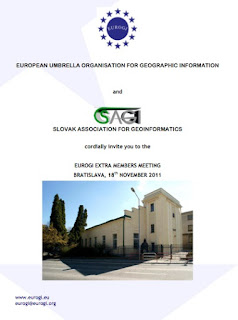
EUROGI EMM - kibővített tagsági nap

A felhívást ma reggel tette közzé az EUROGI főtitkára Catharina Bamps.
EUROGI EMM - Kibővített Tagsági Nap
Színhely: Pozsony
Időpont: 2011. november 18
Vendéglátó: SAGI (Slovakian Association for Geographic Information)
HUNAGI  poszterrel, előadással jelentkezhet, de
az elhangzó előadások kiválasztásában az EUROGI dönt.
Várhatóan az elfogadott, de el nem hangzó előadásokról is kiadvány  jelenik meg.
Részletek: http://www.hunagi.hu/G/doc/Agenda2011EMM.pdf
További részletek: www.eurogi.org
HUNAGI bátorítja tagszervezeteit és tagintézményeit adjanak visszajelzést a HUNAGI felé, amennyiben készek bemutatni  eredményeiket.
Az utazási költségek a HUNAGI tagszervezetet terhelik, részvételi díj nincsen.
Thursday, October 27, 2011

Partnerszervezetünk az MLBKT 19 Kongreszusa Siófokon november 16-18 között

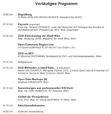
OpenGeoGovData - testvérszervezetünk őszi rendezénye Bécsben

További részletek, jelentkezés: http://www.ageo.at/anmeldung

LIDAR konferencia november végén Salzburgban

Mai postánkból:


"LESS THAN 5 WEEKS TO GO - POINT CLOUD AND OPEN SOURCE DEBATE OPENS THE EUROPEAN LiDAR MAPPING FORUM 2011
A major step forwards or will it damage the industry; should we be supporting Open Source as a way forward for LIDAR technologies? It could open doors to many – or will it result in the closure of a number of industry players and be too high a price to pay? Or consider Point Cloud Services; are these a way to dramatically improve services for customers or is this just evolving technology?

Tuesday, October 25, 2011

EU Űrstratégia Konferencia - ezen a héten még lehet jelentkezni


Ezen a héten még lehet jelentezni az EU Űrstratgiája 4. Konferenciájára. Mai postánkból:
“LAST WEEK TO REGISTER
Deadline for registration: 31 October 2011.
Please be reminded that the 4th High-level Conference on European Space Policy will be taking place on 8 & 9 November 2011 in the Hemicycle of the European Parliament in Brussels, Belgium.

Be sure to register before 31 October 2011. Registration via the Conference website is required and free of charge: www.spaceconference.eu
The Conference will be interpreted in English, French, German and Italian.
This Conference comes at a crucial time:
    a few days after the successful launch of the first two satellites of the future European satellite navigation system, Galileo, which took place on 21 October 2011,
    a few days after the launch by the European Commission of a new tender for additional Galileo satellites,  
    and at a time when the EU Institutions are negotiating the EU’s future Multiannual Financial Framework (2014-2020) (which will determine the timescale and conditions for the completion of the two flagship European space programmes, Galileo and GMES), and the support that is to be given, through the R&D framework “Horizon 2020”, to the development of new innovative space technologies and services.
This event will provide the 700 participants already registered with a perfect opportunity:
    for discussion and debate on current and future EU space policy, its financing and governance, related EU industrial and innovation policy, and the benefits of space-based applications and services for European citizens and businesses, the fight against climate change and environmental degradation, combating security threats, etc.;
    for bringing together key political decision-makers, including representatives of national and European institutions and authorities, and representatives of industry, research centres and civil society.
The event is organised in partnership with the European Commission Directorate-General for Enterprise and Industry, the Committee of the Regions, the European Space Agency, the European Parliament’s Sky and Space Intergroup, Eurospace and other key actors from the space and space-user sector.”

Tuesday, October 18, 2011

ICT Rendezvények

Németh Edina (Nemzeti Innovációs Hivatal) mai postájából:

ICT RENDEZVÉNYEK


Okt.
24-28    Future Internet Week - Poznan, Poland
The next Future Internet Week will be held in Poznan - a series of conferences and exhibition organized by the Ministry of Science and Higher Education and the Poznan Supercomputing and Networking Center, in collaboration with the scientific community of Poznan. This event takes place in the semi-annual cycle, in the countries currently assuming the Presidency of the European Union.

Over 20 events to choose from! A few examples:            
                       Okt. 24.                            Future Internet Conference
                       Okt. 24.                            ENoLL - European Network of Living Labs
                       Okt. 25-26.                       FIA - Future Internet Assembly
                       Okt. 26-28.                       Service Wave 2011
                       Okt. 26-27.                       IOT - The Internet of Things
                       Okt. 26-27.                       ICT Clusters Forum
                       Okt. 26-27.                       FIRE Conference
Okt.
25-26    ARTEMIS and ITEA Co-Summit 2011 - Cross Border Co-operation for Clean Technologies - Helsinki, Finland 
CO-SUMMIT 2011 is expecting over 650 participants from industry, academia, public authorities and press. This year's theme for this high level event is: Cross border challenges for clean technologies. ARTEMIS and ITEA will showcase over 75 cross border projects at the, including a focus area on clean technologies.                    
Okt.
26-28    eChallenges 2011 - e-2011 - Florence, Italy 
eChallenges 2011 is expected to attract over 600 delegates. The goals of e-2011 are to promote ICT knowledge sharing and innovation between commercial organisations, government agencies and the research community, exhange experiences about the current state of eAdoption at a sectoral, national or regional level and stimulate rapid take-up of Research and Technology Development (RTD) results by industry and in particular SMEs.                     
Nov.
11        IPTS – IT STAR International Conference - ICT Research and Innovation Challenges in Eastern European Member States (EEMS) - Budapest, Hungary 
Eastern EU Member States have very low ICT business expenditures in ICT R&D in relation to their GDP. They also show a very low rate of ICT public expenditures in R&D in relation to their GDP. Although several of them have recorded spectacular increases in ICT manufacturing employment, deeper analysis tends to indicate that these countries are still hosting rather low value added activities. 
The mission of this conference is to confront such facts and views to the testimony of the stakeholders from academia, industry and policy so as to validate the observations, interpret their possible meaning and opt for actions that might favorably influence the future.             
Nov.
15        Digital Preservation and Access to Cultural Resources: ICT Call 9 Information Da - Luxembourg 
This event addresses researchers interested in submitting project proposals to the 9th ICT call under FP7, objectives ICT-2011.4.3 Digital Preservation and 8.2 Access to Cultural Resources. The information day aims at helping participants to better understand the work programme and criteria for the evaluation of proposals, to facilitate sharing of ideas and experiences, and to meet potential partners for project consortia.                 
Nov.
15-16   European Nanoelectronics Forum 2011 - Dublin, Ireland 
The European Nanoelectronics Forum is organised by the Joint Technology Initiative ENIAC and the Eureka Cluster Catrene (Cluster for Application and Technology Research in Europe on NanoElectronics) in Dublin, Ireland. Invitations can be requested on the event website.                     
Dec.
5-6           Innovation Convention 2011 - Brussels, Belgium 
The European Commission is holding its first Innovation Convention following the adoption of the Innovation Union Flagship initiative in October 2010. This major event will gather more than 1200 participants involved in the innovation chain, including high-level policy makers, leading CEOs, deans of universities and research centres, bankers, venture capitalists, top researchers and innovators.

Friday, October 7, 2011

GeoBusinessCongress Berlinben


Mai postánkból: a "jövő szolgáltatásai és a ma társadalma" a témája a berlini GeoBusiness kongresszusnak. HUNAGI beszámol majd az elérhető információkról.
"Einladung zum Jahreskongress 
"Dienste der Zukunft - Bereit für die Gesellschaft von heute?"

Donnerstag, 3. November 2011 von 10:15 Uhr bis 15:00 Uhr 
Konferenzzentrum des Bundesministeriums für Wirtschaft und Technologie 
Scharnhorststraße 34-37, Eingang Invalidenstraße 48, 10115 Berlin 


Sehr geehrte Damen und Herren,

wir laden Sie herzlich zum gemeinsamen Kongress der Initiative D21 und der Kommission für Geoinformationswirtschaft in das Konferenzzentrum des Bundesministeriums für Wirtschaft und Technologie in Berlin ein. "Dienste der Zukunft - Bereit für die Gesellschaft von heute?", so das Thema der diesjährigen Veranstaltung, auf der Expertinnen und Experten aus den unterschiedlichsten Bereichen über die Rahmenbedingungen für moderne Dienste der Zukunft diskutieren.

Im Mittelpunkt der Vorträge und Workshops stehen Themen wie Vertrauen, Verlässlichkeit und Strategien für digitale Dienste von morgen für die Gesellschaft von heute. 

Wir freuen uns auf Ihre Teilnahme und bitten um Ihre Anmeldung bis zum 27. Oktober 2011 unter: 
www.initiatived21.de/anmeldung oder www.GeoBusinessCongress.org. 


Programm
10:15 Uhr:
Begrüßung
PStS Hans-Joachim Otto, Bundesministerium für Wirtschaft und Technologie
Hannes Schwaderer, Präsident Initiative D21, Geschäftsführer Intel GmbH
10:30 Uhr:
Open Data und Publizistik, wie informiere ich die Menschen? Joachim Mahrholdt, (ZDF)
11:00 Uhr:
Digitale Dienste für die Mobilität der Zukunft Dr. Martin Weiser, Volkswagen Aktiengesellschaft
11:30 Uhr:
Kaffeepause
12:00 Uhr:
Parallele Workshops 
Workshop 1: Geoinformationen und die Gesellschaft von morgen 
Moderation: Wolfgang Naujokat (ESG/Initiative D21)
- Welche strategische Rolle spielt GeoBusiness für die Gesellschaft von morgen in Deutschland, Europa und der Welt? (Stefan Rösner, D-GEO/DWD) 
- Welche Dienste sind bereits jetzt abzusehen? (Dr. Andreas Goerdeler, BMWi) - Wie kann die Gesellschaft an diese Dienste herangeführt werden? (Joachim Mahrholdt, ZDF)
Workshop 2: Dienste der Zukunft für die Gesellschaft von heute. Wie Vertrauen schaffen? 
Moderation: Andreas Mann, (MDR)
- Vertrauen in die Technik schaffen - eine gesamtgesellschaftliche Aufgabe (Olaf Keitzel, CSC, angefragt)
- Vertrauen in das Management und seinen Umgang mit Daten schaffen - wie viel Verlässlichkeit und Authentizität sollte ein Unternehmen sich leisten? (Dr. Thilo Weichert, ULD Kiel)
- Vertrauen in die Anbieter moderner Internetdienste schaffen (Dr. Max Senges, Google)
13:00 Uhr:
Mittagspause
14:00 Uhr:
Abschlussrunde 
Moderatoren, Keynote Speaker
14:30 Uhr:
Kongressende mit Kaffee


Kontakt
Initiative D21 e.V. Kommission für Geoinformationswirtschaft Tel.: 030/526 87 22 50  Tel.: 0511/643 29 97        E-Mail: kontakt@initiatived21.de"                  

Tuesday, October 4, 2011

GSDI13: közeleg az előadások beküldésének határideje!


Prof.Harlan Onsrud, a GSDI ügyvezető igazgatója küldött figyelemfelhívást. Már csak hat hét van hátra a GSDI13 konferencia előadás-beküldési határidejéig!
“Dear Members of the Geospatial/Geomatics Community,
We remind you that there are only six weeks left before the deadline for abstracts and full paper submissions for Global Geospatial Conference 2012.
The Call for Papers may be found at http://www.gsdi.org/gsdiconf/gsdi13/papers.html and the deadline for abstracts and/or papers for the refereed and non-refereed publications is November 15.
This conference will be a leading event in 2012 for engaging the geospatial scholarly, government agency and industry communities. The event combines the GSDI 13 World Conference, the 14th GEOIDE Annual Scientific Conference, the 7th 3D GeoInfo Conference and the Canadian Geomatics Conference 2012.

The overall theme for the conference is Spatially Enabling Government, Industry, and Citizens and provides numerous opportunities for oral presentations as well as several refereed and non-refereed publication outlets.
The program features a rich range of plenary and technical sessions along with workshops, poster session, lightning rounds, business meetings, and social events. Highlights also include a major commercial exhibition and industry showcase.
Save the dates! Come and enjoy beautiful historic Quebec City with your professional peers in May 2012.
Best regards,
Joint Organizing Committee
Global Geospatial Conference 2012
+++++++++++++++++
CONFERENCE LINKS
Joint Conference Call for Abstracts and Papers: http://www.gsdi.org/gsdiconf/gsdi13/papers.html
Conference Website: http://www.gsdi.org/gsdi13
Past GSDI World Conference Proceedings: http://www.gsdi.org/gsdiConferences
Past open access Books affiliated with the conference: http://www.gsdi.org/openaccessbooks
****************************
If a friend or colleague would like to sign up for the GSDI News List,
direct them to http://www.gsdi.org/
To unsubscribe/change profile:
To subscribe:
Our address:
c/o Onsrud | 5711 Boardman Hall, Univ. of Maine  | Orono, Maine 04473”
HUNAGI bátorítja tagjait és partnereit, éljenek a lehetőséggel és számoljanak be fejlesztési eredményeikről, alkalmazásaikról.

Saturday, October 1, 2011

GDi - Esri felhasználói és GISDATA nemzetközi konferencia

Illusztráció és forrás: Kis Ágnes (Esri Magyarország Kft) jóvotából

Konferencia előzetes:

- Közel 50 előadással, 8 szekcióval, 4 teremben várjuk az érdeklődőket! Minden teremben szinkrontolmácsolás biztosított.
- Idén több nemzetközi és országos szervezet felsővezetője és szakértője tart előadást többek között azEgységes segélyhívó rendszerről, a Regionális és helyi önkormányzatok helyzetalapú webes információ szolgáltatásairól, a népesség nyilvántartás térinformatikai támogatásáról, az árvízi kockázatok kezeléséről, dinamikus útvonaltervezésről, transzmodell alapú megoldásokról, energetikai kutatások térinformatikai hátteréről illetve további alkalmazási példákat műszaki, telekommunikációs, környezetvédelmi, területhasznosítási és kockázatelemzési témakörökben.
- A plenáris szekcióban előadást hallhatnak aCityEngine – 3D-s városmodellezésről – amely segítségével lehetőség nyílik utcahálózatok és épületek 3D szerkesztésére. A várostervezés mellett katonai célokra és szimulációk készítésére is alkalmas, illetve a szórakoztató iparban is használható minőségi 3D tartalom előállítására.
- A technikai szekciókban a fejlesztők élőben, interaktív formában mutatják be az Esri szoftverek legfrissebb verziójának újdonságait - a ArcGIS 10.1 verziót - és fejlesztések eredményeit. A szekció délelőtti és délutáni ismétléssel várja az érdeklődőket; a „demo island" standok pedig alkalmat adnak a szoftverek élőben való kipróbálására.
- A Poszter/Térkép kiállításon résztvevőknek lehetősége lesz bemutatni saját projektjüket, amelyek közül a legjobbak a konferencia végén díjazásban részesülnek.
- A konferencia teljes ideje alatt díjmentes szakmai konzultációt tart két fejlesztő kollégánk a kiállítói területen.
- Bemutatásra kerül a Panasonic megújult terepre szánt „páncélozott” laptop családja: a Toughbook – ütés, víz, por és rezgésálló laptopok http://www.toughbook.eu. Megtekinthetik a következő szponzorok bemutatkozó standjait: NAVTEQ, Telcordia, I-Com, START-IT illetveTRIMBLE termékbemutató és tesztelési lehetőség.
- A rendezvény első napjának zárásaként gála vacsora várja a résztvevőket, amelyen koncertet ad Zséda, aki ismert dalokat, világslágereket, jazzklasszikusokat, valamint legkedveltebb saját dalait énekli egyedi hangszerelésben, zongora kísérettel.
….
Kérdéseivel keressen minket bizalommal, a következő e-mail címen: info@gdi2011.hu. További információ, program a konferencia oldalán található: www.gdi2011.hu

GSDI/HUNAGI a GEO VIII plenáris ülésen


GEO honlap:
http://www.earthobservations.org
Magyarország a GEO 67. tagországa
GEO VIII Plenáris ülés honlapja:
http://www.earthobservations.org/meetings/geo8.html
A GSDI delegációban helyet kapott a HUNAGI képviselője is:

"...the approved Delegation List to GEO-VIII from the GSDI Association includes the following individuals.
Gabor Remetey-Fülöpp, Head of Delegation
Ivan B. DeLoatch, Executive Director, Federal Geographic Data Committee, US
David Lovell, Executive Director, EuroGeographics"