HUNAGI Napló legutóbbi látogatói

Címkék

#SDG11 14. ICGC 2030 Agenda 20th ISDE 3D 3D city modelling 3D city models 3D SIG 4-es metró 5. Digital Earth Summit 5. Térinformatikai Konferencia és Szakkiállítás 6th Digital Earth Summit 7 ICC&GIS adatpolitika Afrika Expo és Vásár Agenda 2030 AGEO AGILE AGILE 2014 Agile 2015 AGILE 2017 AGIT AGIT Expo Agrárinformatika Agriculture AgriFuture Appathon ARSET ASGC Atlas Human Planet 2018 Award Bernhard Harzer Verlag Best Practice BiDS 14 Big Data Big Data from Space Big Spatial Data BIM biodiversity BKK BME BME ÁGT BME VIK EIT BMWi Cadastre 2.0 CAGI cartographic heritage Cascadoss CeDEM Center for Open Data Enterprise CEODE CEOS CEOS WGISS CGS Chubu citySDK CitySmart CLGE CME CODATA conservation COP23 Copernicus Copernicus Masters Copernicus MPP CORP 2017 CORP2017 COSPAR COSPAR 2014 CSIRO Danube Data Cube Danube Participation Day of the Danube Strategy Danube Reference Data Service Infrastructure Danube_Net Data Archives Data Curation Data Documentation Initiative Data Economy data policy DCH2017 DDI DE Summit DE TGT Debrecen Debreceni Egyetem Földtudományi Intézet Defense Defense imagery Information Deqing DES 2018 DGI Digital Approaches to Cartographic Heritage Digital cartography digital cultural heritage Digital Earth Digital Earth in a Transformed Society Digital Earth Session Digital Earth Summit Digital Earth Summit 2016 Digital Earth Symposium Digital Map Heritage Digital repository Digitális Föld Digitális Föld Csúcs Digitális kulturális örökség digitális térképi örökség Disaster Disaster management Disaster Risk Disaster risk assessment DLR Doha Draught Risk Management DRDS DRDSI drones Drónok Duna Adatkocka Duna Stratégia Duna-régió Stratégia DUT e-Government e-learning courses EuroSDR EARSeL ECAI ECAI PNC ecosystems éghajlatváltozás élelmiszerbiztonság ELF ELTE ELTE IK TGT ELTE TGT ENSZ ENSZ Klíma Csúcs Environment EO EO4Alps EO4climate EO4SDG EoE EoE webinar ESA ESA ESRIN ESD ESDI-NET ESDINET ESPON Esri Esri Magyarország ESRIN Ethical reuse of data EU EU BIG IoT EU citySDK EU Data Innovation Forum EU Space Imaging EUGEO EUGEO2017 EULF EULIS EURISY EuroGeo EuroGEOSS EuroGEOSS broker EUROGI European Cohesion Policy European Lidar Mapping Forum European Space SolutionsKép: EuroSDR EuroSDR 3D EuroSDR JRC EUSDR Eye on Earth Eye on Earth Symposium Eye on Earth webinar fenntartható fejlődés FÉNY - TÉR - KÉP 2017 FÉNY-TÉR-KÉP FÉNY-TÉR-KÉP 2016 FÉNYKÉP FÉNYKÉP TÉRKÉP FET FF célok FFC FGDC FI Working Week 2017 FIG FIG Hanoi FIG Helsinki FIG Working Week FIG Working Week 2017 Föld-rendszer földhasználat földmegfigyelés földművelés földtudomány FÖMI FOSS Academy FOSS4G FOSS4G 2016 FOSS4G 2017 FOSS4G 2018 FOSS4G HU FOSS4G-Asia FOSS4G-Europe FOSS4G-HU FOSS4G.HU Foszforgézu Foszforgézúúúú Fotogrammetria Future Internet FuturICT Galway GaphiTech GCOS GDI Fórum GDI Sachsen Geiger-Mode LiDAR GEO GEO Business 2014 GEO Data and Knowledge Week GEO Data Providers Geo Delft 2018 GEO European Projects GEO Exhibit GEO Week 2017F GEO Week 2018 GEO XI Geo-ethics Geo-etika Geo-IT Geoadat GeoBIM GeoBIM Europe GeoBusiness GeoBusinessFORUM Geographic Information Science Geography of Europe Geoinformatics 2016 Geoinformatics Potsdam geoinformatika gazdaság geoinformatikai piac GeoIQ GEOMAT 2014 Geonovum Geoscience Australia Geospatial data Geospatial Intelligence Geospatial Summit Geospatial World Forum Geospatial World Forum 2016 Geospatial World Forum 2017 GEOSS GeoSUR GI EO SDG GI Forum GI Humanitarian Assistance GI services GI_Forum 2015 GI-18 GI-Forum GIM International Summit GIS GIS Open 2017 GIS Ostrava GIS Ostrava 2016 GIS-education Gisday GISopen GISopen 2016 GISopen 2017 grid computing Clouds GSDI GSTIC GWF GWF 2016 H-SPACE 2017 H2020 Health Helmholtz-Zentrum für Umweltforschung heritage management Hexagon Horizon 2020 HUNAGI HUNAGI ISPIK HUNGEO 2014 HUNSPACE HxGN HxGN 2015 ICA ICA-OSGEO ICC&GIS ICSU ICSU CODATA ICT ICT Family Farming Ideal-IST IDEAS IGARSS IGIT IGIT 2005 IJDE ILUS 2019 imaGIne 2 Indicator reporting Információs Társadalom Parlamentje information age Infotér Infotér 2014 Infoterra Innotrends 2014 Innovation INSPIRE INSPIRE 2014 INSPIRE 2015 INSPIRE 2016 INSPIRE konferencia 2016 INSPIRE validation Intelligens városok INTERGEO 2011 Intergeo 2014 INTERGEO 2015 Intergraph International Map Year Internet of Things interoperabilitás interoperability Interspect IoT IRIS ISA ISDE ISDE 9 ISDE Digital Earth European Chapter ISDE Florence ISDE10 isde7 ISDE9 ISEH ISGC 2016 ISPRS ISPRS kongresszus ISPRS Prága ISPRS XXIII Congress ITP JAXA Jövő internet JRC Kartografija.hr Kartverket Katasztrófa menedzsment képfeldolgozás Kereskedelmi lehetőségek Afrikában knowledge kockázatelemzés Kommission für Geoinformationswirtschaft KRF KU Leuven Landsat laser scanning LBS Leica Library Library Information Lidar Lidar 2014 LIDAR forestry lidar mapping Lipszy János LISC75 Living Planet Living Planet 2016 Locate17 MAGISZ Magyar Földrajzi Napok MANT Mapinfo MFGVE MFT MFTTT Mitteldeutschen GEOforum MMK-GGT mobility MTA SZTAKI MŰI Mundo GEO Museum Allience MUT Nagy Adatok NAIH NASA NASA ARC NASA World Wind népességnövekedés Next GEOSS Next GEOSS training NextGEOSS NHIT NIH NMCA NMCA Summit NMHH Norvég Alap NRC nyfsz NyME GEO Oblique Aerial Camera Systems ODC ÓE AMK OGC OGRS okos város Del Bianco CitySmart OMSZ Open data Open data business models Open Data Cube Open Geodata Open Government Data open source Open source Geospatial Open source Geospatial Education Open source Geospatial Research Open source Open data Open Standards for BIM OSGeo OSGeo Lab Budapest Ossiach Klub OSZK Paris Agreement Patrick Hogan Pitney Bowes Software Plan4all PNC 2016 Prof. Carsten Jürgens QGIS QGIS HackFest RADI Rasdaman RDA REAL CORP 2017 Recovery Regional Development remote sensing Resource Watch RESTEC Road to dignity RPAS RT&I Sächsisches GIS-Forum SAGI SAR for mapping SatCen SD SDG SDG Academy SDG National Reporting SDG reporting SDGs SDI SDI Day SEE sensor web Sentinel Sentinel-2 Smart cities Smart City smarter cities smeSpire Societal Geo-Innovation Socioeconomic potential of Land Administration Services spatial planning SPL LiDAR Strategy on SDG National Reporting STSN Sustainable City Swiss Data Cube szenzor háló Szép Magyar Térkép Szép magyar térkép 2015 Szép Magyar Térkép 2016 Tabula Hungariae társadalmasítás távérzékelés téradatok üzleti modellek térinformatika Térinformatika oktatása Térinformatikai Konferencia TÉRKÉP Térképészet térszkennelés Törökbálint Travel Award DES 2018 UAS UAV ubiquitous e-infrastructure UHI UN 2030 Agenda UN Agenda 2020 UN Climate Summit UN SDSN UN-GGIM UN-SPIDER UNIGIS Summer School University of Geneva UNOOSA UNWGIC Urban Remote Sensing Urban transitions Űripar űrkutatás VARINEX városi hősziget városiasodás várostervezés Versenyképesség VGI Wageningen WDS We Act4SDGs Webinar European Location Framework WGISS WGISS 46 Wo? kongresszus World Summit Information Society WPLA WSIS WWEC WWEC 2014 WWEC 2015 WWEC 2016 WWEC 2017 WWEC Helsinki Z_GIS

Saturday, April 25, 2009

SemSensWeb 2009

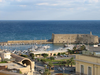
Heraklion, Old Harbour. Image: HUNAGI Visuals resource, 2007
1st International Workshop on the Semantic Sensor Web
Collocated with the 6th European Semantic Web Conference (ESWC 2009)
Heraklion, Crete (Greece)
1 Jun 09
The Semantic Sensor Web unifies the real and the virtual world by integrating sensor technologies and Semantic Web technologies. Topics include:
Data models and languages for the Semantic Sensor Web
Architectures and middleware for the Semantic Sensor Web
Ontologies and rules for the Semantic Sensor Web * Annotation tools for the Semantic Sensor Web
Semantic data integration of heterogeneous sensor network data streams
Registries for the Semantic Sensor Web * Mashup technologies for the Semantic Sensor Web
Semantic Sensor Web applications
Invited are research papers and demos.
Deployed technologies (sensors, middleware and mashups) are important if the Semantic Sensor Web is to be realized.
Source: AGILE website: http://plone.itc.nl/agile/events/semsensweb-2009 or simply click on the header
HUNAGI is the National GI Association having nearly one hundred members.
For more information on Geospatial Hungary please visit
http:// www.hunagi.hu and its linked interactive blogsites devoted to GI, SDI technologies and services e.g. http://hunagi8.blogspot.com or
http://unsdihu.blogspot.com

9. Szász Térinformatikai Fórum

From our daily mail: information extract from the circular sent by academician Frank Hoffmann today:

GI2009-Symposium-DRESDEN:
14./15.05.2009
( 9. Sächsisches GIS-Forum )

CREATIVITY & INNOVATIONS - AGRO, ENVIRO, SPATIO -
X-PSI, X-INSPIRE, X-GDI, Web2.0, SDI2.0
Automated Generalization across Europe(see press release ! )
OPENSOURCE, OPEN GEODATA, OPENSEARCH
and more...
ALLE Registration & INFO Files, compressed (ca. 800KB, ZIP folder)
[ http://www.cagi.cz/akcevypis.php?id=475 ]
[ http://www.IGN-SN.de/GI2009/GI2009-Desktop.zip ]
[*] ATTN.:
[ only a very few pre-reservated pension rooms (33,-€) are still yet open! ]
AKTUELL:
> 35 Papers / Posters / Workshops have been registrated from OPEN CALL !
DRAFT-Programme:
[ http://www.ign-sn.de/GI2009/GI2009-Agenda-DRAFT-Version-20090421.pdf]
PRESS RELEASE:
[ http://www.1spatial.com/news_events/news/news.php?news=293&&PHPSESS ]
--
IGN e.V. [FH] / 10:30
--
IGN e.V.
VORSTAND: [ Mailto:info@GDI-SN.de ]
IGN: FEEDS@WEBLOG [ http://GDI-SN.blogspot.com/feeds/posts/default ]
----------------------------------------------------------------------
GI2009: WEBLOG [ http://GDI-SN.blogspot.com ]
GI2009: EMAIL [ Mailto:GI2009@IGN-SN.de ]
GI2009: SKYPE [ Callto:FH_IGN ]
----------------------------------------------------------------------
DRAFT - Programm - ENTWURF
(see URL above - TOP 2 & 3 - siehe oben) !
----------------------------------------------------------------------
DEADLINE for Pre-Registration of Participants: 30.04.2009 *)
[ http://www.IGN-SN.de/GI2009/GI2009-Anmeldung-NAME.doc ]
NO conference fee, but a "Social event/Catering/Service" fee = 40€ **)
*) For active authors = 20€ # 50% for CEEC participants = 20€
*) For pensioners/students only 25% = 10€ /without social event = 5€
**) as from 01.05.2009 full SocialEvent/Catering/Service fee = 60€
DEADLINE FINAL Participants REGISTRATION : 10.05.2009
----------------------------------------------------------------------
DEADLINE for Authors' Presentations (ppt) delivery: 10.05.2009
----------------------------------------------------------------------
GI2009-Symposium-OPENING: 14.05.2009 / 10:00
GPS: [ 51°01'15.52"N, 13°43'44,78"E ]
Mobile Hotline: +49-160-9490.2443


HUNAGI is the National GI Association having over one hundred members.
For more information on Geospatial Hungary please visit
http:// www.hunagi.hu and its linked interactive blogsites devoted to GI, SDI technologies and services e.g. http://hunagi8.blogspot.com or
http://unsdihu.blogspot.com

Wednesday, April 15, 2009

Közös EUROGI-INSPIRE-CAGI és PROGIS konferencia Prágában

Mai postánkból:

Bővebb információ: http://www.progis.com/events/progis09/

HUNAGI is the National GI Association having nearly one hundred members.
For more information on Geospatial Hungary please visit
http:// www.hunagi.hu and its linked interactive blogsites devoted to GI, SDI technologies and services e.g. http://hunagi8.blogspot.com or
http://unsdihu.blogspot.com

Monday, April 13, 2009

GEO-SIBERIA Exhibition and Conference in Novosibirsk

The Fifth International Exhibition and Scientific Congress in geodesy, cartography, geology, geophysics, land management, real property cadastre, GIS-technologies, forestry management, environmental monitoring.
“SIBMINING-2009” will be held along with the exhibition and the scientific congress “GEOSIBERIA-2009” on the 21-23 April.
21-23 APRIL 2009, NOVOSIBIRSK
Introduction of Geographic Information Systems, newest equipment and high qualified staff in all geo-industry is necessary to realize new state programs aimed on increase in sector of civil and industrial construction and environmental management regulation.
Siberian forum "GEO-Siberia" became the first project with a similar theme in Siberia Far East regions, combining International scientific congress and exhibition.
Siberian State Geodetic Academy acted as fully legitimate organizer of this event, this made it possible to present exhibition-congress scientific component remarkably, and also to attract Russian Academy of Science Siberian Branch profile institutes, Moscow State University of Geodesy and Cartography, Tomsk Polytechnic University and other institutions.
In 2004 after visit of Siberian Region's representatives to "INTERGEO" exhibition in Munich, "GEO-SIBERIA" exhibition received international support from "German Association of Publicly Appointed Surveyors", "German Cartographers Association" who are inspirers and organizers of world famous exhibition "INTERGEO".
Russian public organization "GIS-ASSOCIATION", understanding project importance, supported "GEO-Siberia".
The main task of this forum - to get acquainted with advanced experience; demonstration of modern means, methods and technologies of efficient environmental management and perspective regional investment projects; and also an opportunity to analyze real processes in this sector of the economy.
In experts' unanimous opinion "GEO-SIBERIA - 2008" was very successful. Numerous positive references about the exhibition prove its actuality and great importance.
World famous companies: Leica Geosystems AG (Switzerland), SOVZOND, SOVINFORMSPUTNIK, GEOKOSMOS, RAKURS, SCANEX, NAVGEOKOM, SIBGEOINFORM, Regional Cadastral Centre "ZEMLYA" and other Russian and foreign companies supported and participated in "GEO-Siberia-2008" exhibition-congress. Now annually, in the end of April the widest range of geo-industry experts from different cities of Russia have an opportunity to exchange information, experience, get acquainted with the newest equipment, methods, technologies demanded by time and life.

HUNAGI is the National GI Association having nearly one hundred members. For more information on Geospatial Hungary please visit http:// www.hunagi.hu and its linked interactive blogsites devoted to GI, SDI technologies and services e.g. http://hunagi8.blogspot.com or http://unsdihu.blogspot.com

Digitális fotogrammetriai technológiák

Mai postánkból. A moszkvai RACURS cég 2009 október 5-8 között a görögországi Atticában konferenciát szervez "A képalkotástól a térképig" címmel. Ime a figyelemfelhívó levél:
"Dear colleagues!
It's our great pleasure to invite you to the IXth International Scientific and Technical Conference "From imagery to map: digital photogrammetric technologies".
The Conference is a combination of activities in the form of sessions, seminars, workshops and appointments covering up-to-date photogrammetric and remote sensing technologies. It is an area for discussing, getting knowledge and sharing experience in the field of the mentioned themes.
The Conference has been held for nine years and a range of participants each year is increasing. Permanent participants of the conference are representatives of the FSUE "Goszemcadastrysiomka" - VISHAGI (Russia), the Federal Real Estate Cadastre Agency of Russia, the Federal Agency of Geodesy and Cartography (Russia), NP AGP "Meridian +" (Russia), VNIIGAZ (Russia), JSC "Surgutneftegas" (Russia), EUROSENSE, Leica Geosystems (Switzerland), Spot Image (France), MapWorld Technologies Limited (India), GEODIS (Czech Republic), GeoEye (USA) and many others. In 2007-2008 reports on current topics of development of photogrammetry and remote sensing were presented by recognized authorities in this area, such as Gordon Petrie (UK), Gottfried Konecny (Germany), Franz Leberl (Austria).
The Conference is the perfect opportunity to learn the latest news in the area of airborne and space digital cameras, remote sensing data, software development, practice of using digital photogrammetry in different economic activities and in integrated geoinformatic solutions based on remote sensing data.
The heads and leading specialists from Russian land cadastre and cartography state agencies, gas and oil enterprises as well as representatives of foreign photogrammetric, GIS and remote sensing companies will participate in the Conference.
Conference organizer: Racurs (Moscow, Russia)
Location: Attica, Greece
Date: October 5-8, 2009
Conference topics:
Digital photogrammetry:
- Current state and main lines of development;
- Technologies and facilities of remote sensing data processing. Modern software solutions;
- Digital photogrammetric technologies for practical applications.
Remote sensing methods and techniques:
- Advanced survey systems - market review;
- Modern digital aerial cameras. Direct georeferencing methods, airborne GPS/IMU;
- Derivation and applications of satellite imagery;
- Technological features of synthetic aperture radar survey.
Within the frame of Conference the IXth International PHOTOMOD User Conference will be held. For the participation in the contest it is necessary to send to Racurs a brief project description.
We invite our partners, sponsors, friends and all comers to take part in the conference!
More detailed information will be available shortly at our Web site.
Best regards,
Racurs Company
+7-495-720-5127 +7-495-720-5128 info@racurs.ru"
Bóvebb hátérinformáció a RACURS cég honlapján, a címre kattintva.

HUNAGI is the National GI Association having over one hundred members.
For more information on Geospatial Hungary please visit
http:// www.hunagi.hu and its linked interactive blogsites devoted to GI, SDI technologies and services e.g. http://hunagi8.blogspot.com or
http://unsdihu.blogspot.com

Thursday, April 9, 2009

Multimodális közlekedési megoldások

Mai postánkból. Prof.Dr.Lindenbach Ágnes, partnerszervezetünk az ITS Hungary főtitkár asszonya írja:
" Tisztelt Kollégák!
ezúton tájékoztatom Önöket, hogy a legközelebbi szakmai programunk a következő:
Szakmai bemutató: "Háztól házig multimodális közlekedéssel"
Tartja: Topolisz Térinformatikai Stúdió Kft.
Időpont: 2009. május 5. (kedd) 14.30-kor
Helyszín: Griff Irodaház, 1113 Budapest, Bartók Béla u. 152.
Tekintettel arra, hogy a multimodális közlekedési megoldások az intelligens közlekedési rendszerek egyik aktuális témája, bízom benne, hogy az ITS Hungary Egyesület tagjai számára ez a téma érdeklődésre tarthat számon.
Részvételüket felém e-mailben jelezni szíveskedjenek.
Tájékoztatom Önöket, hogy a legközelebbi szakmai programunk június elején a CONNECT projekt III. fázisa legérdekesebb projektjeinak ismertetése lesz.
Kérem továbbá, hogy további programajánlataikat számomra minél előbb megadni szíveskedjenek.

Üdvözlettel:
Dr. Lindenbach Ágnes
főtitkár
ITS HUNGARY
H-1113 Budapest, Bartók Béla út 152.
Tel./Fax.: + 36 1 203 1206
E-mail: itshungary@tvnetwork.hu"


HUNAGI is the National GI Association having over one hundred members.
For more information on Geospatial Hungary please visit
http:// www.hunagi.hu and its linked interactive blogsites devoted to GI, SDI technologies and services e.g. http://hunagi8.blogspot.com or
http://unsdihu.blogspot.com

Monday, April 6, 2009

PSI Alliance - 2009 Annual Conference and General Assembly

From our daily mail. PSI Platform submitted this information today:

*2009 Annual Conference and General Assembly*

on Thursday 25th June at 10am – 4pm

at The Residence Palace, Brussel
s

The PSI Alliance was established in order to encourage the public sector to maintain a trading environment that is fair and equitable, in particular in relation to the licensing and re-use of public sector information (PSI).
Our members are private sector companies and associations who are committed to working with PSI holders towards the maintenance and development of a vibrant, information-driven EU economy that ultimately works to the benefit of the public sector, private sector and the end consumer.
Please find attached the Conference Agenda and information about the PSI Alliance. Speakers at the Annual Conference include representatives from *DG Information Society and Media*, the *Swedish Competition Authority* and the *Ministry for Public Information in Slovenia*.
The conference is free to PSI Alliance members and for non members is 95 Euros (plus VAT) before 31^st May or 150 Euros (plus VAT) before 25^th June. Any non-member who attends the conference and then joins the PSI Alliance will have their conference fee deducted from the cost of membership.
For further information and to RSVP please contact Harriet Crosthwaite:
harriet@quintuspa.com
, Tel: +44 (0) 20 7340 6260
Bővebb információ www.psialliance.eu
, vagy a címre kattintással.

HUNAGI is the National GI Association having over one hundred members.
For more information on Geospatial Hungary please visit
http:// www.hunagi.hu and its linked interactive blogsites devoted to GI, SDI technologies and services e.g. http://hunagi8.blogspot.com or
http://unsdihu.blogspot.com

Saturday, April 4, 2009

GI 2009 Dresden


HUNAGI is the National GI Association having over one hundred members.
For more information on Geospatial Hungary please visit
http:// www.hunagi.hu and its linked interactive blogsites devoted to GI, SDI technologies and services e.g. http://hunagi8.blogspot.com or
http://unsdihu.blogspot.com

Friday, April 3, 2009

GEOSS Data Sharing Task Force Meeting

GEOSS Data Sharing Task Force
GEO Secretariat, Geneva
27-28 May

Just received via the GEO Secretariat as GSDI GEOSS correspondent.
"A Kick-off meeting will be held on 27-28 May 2009, at the GEO Secretariat in Geneva, Switzerland. The objectives of this meeting are to initiate the activities of the Task Force, familiarize the members with the work of the previous Task Team: the GEOSS Data Sharing Principles Process Paper and Implementation Guidelines. Building on these works, in accordance with the Cape Town Declaration, the Data Sharing Task Force will initiate discussions to develop guidelines to be presented at GEO-VI and then finalize them for adoption by the 2010 GEO Ministerial Summit."
GSDI Association will be presented by Executive Director Prof. Harlan Onsrud. US Delegation has among its members Martha Maiden (former CEOS WGISS Chair, NASA) and Ivan DeLoatch (Director, USGS FGDC).

Background Documents:
Process Paper on GEOSS Data Sharing Principles
Implementation Guidelines
Response to review Comments
GEO Work Plan 2009-2011 Task Sheet
(All available on GEO website)

HUNAGI is the National GI Association having over one hundred members.
For more information on Geospatial Hungary please visit
http:// www.hunagi.hu and its linked interactive blogsites devoted to GI, SDI technologies and services e.g. http://hunagi8.blogspot.com or
http://unsdihu.blogspot.com