HUNAGI Napló legutóbbi látogatói

Címkék

#SDG11 14. ICGC 2030 Agenda 20th ISDE 3D 3D city modelling 3D city models 3D SIG 4-es metró 5. Digital Earth Summit 5. Térinformatikai Konferencia és Szakkiállítás 6th Digital Earth Summit 7 ICC&GIS adatpolitika Afrika Expo és Vásár Agenda 2030 AGEO AGILE AGILE 2014 Agile 2015 AGILE 2017 AGIT AGIT Expo Agrárinformatika Agriculture AgriFuture Appathon ARSET ASGC Atlas Human Planet 2018 Award Bernhard Harzer Verlag Best Practice BiDS 14 Big Data Big Data from Space Big Spatial Data BIM biodiversity BKK BME BME ÁGT BME VIK EIT BMWi Cadastre 2.0 CAGI cartographic heritage Cascadoss CeDEM Center for Open Data Enterprise CEODE CEOS CEOS WGISS CGS Chubu citySDK CitySmart CLGE CME CODATA conservation COP23 Copernicus Copernicus Masters Copernicus MPP CORP 2017 CORP2017 COSPAR COSPAR 2014 CSIRO Danube Data Cube Danube Participation Day of the Danube Strategy Danube Reference Data Service Infrastructure Danube_Net Data Archives Data Curation Data Documentation Initiative Data Economy data policy DCH2017 DDI DE Summit DE TGT Debrecen Debreceni Egyetem Földtudományi Intézet Defense Defense imagery Information Deqing DES 2018 DGI Digital Approaches to Cartographic Heritage Digital cartography digital cultural heritage Digital Earth Digital Earth in a Transformed Society Digital Earth Session Digital Earth Summit Digital Earth Summit 2016 Digital Earth Symposium Digital Map Heritage Digital repository Digitális Föld Digitális Föld Csúcs Digitális kulturális örökség digitális térképi örökség Disaster Disaster management Disaster Risk Disaster risk assessment DLR Doha Draught Risk Management DRDS DRDSI drones Drónok Duna Adatkocka Duna Stratégia Duna-régió Stratégia DUT e-Government e-learning courses EuroSDR EARSeL ECAI ECAI PNC ecosystems éghajlatváltozás élelmiszerbiztonság ELF ELTE ELTE IK TGT ELTE TGT ENSZ ENSZ Klíma Csúcs Environment EO EO4Alps EO4climate EO4SDG EoE EoE webinar ESA ESA ESRIN ESD ESDI-NET ESDINET ESPON Esri Esri Magyarország ESRIN Ethical reuse of data EU EU BIG IoT EU citySDK EU Data Innovation Forum EU Space Imaging EUGEO EUGEO2017 EULF EULIS EURISY EuroGeo EuroGEOSS EuroGEOSS broker EUROGI European Cohesion Policy European Lidar Mapping Forum European Space SolutionsKép: EuroSDR EuroSDR 3D EuroSDR JRC EUSDR Eye on Earth Eye on Earth Symposium Eye on Earth webinar fenntartható fejlődés FÉNY - TÉR - KÉP 2017 FÉNY-TÉR-KÉP FÉNY-TÉR-KÉP 2016 FÉNYKÉP FÉNYKÉP TÉRKÉP FET FF célok FFC FGDC FI Working Week 2017 FIG FIG Hanoi FIG Helsinki FIG Working Week FIG Working Week 2017 Föld-rendszer földhasználat földmegfigyelés földművelés földtudomány FÖMI FOSS Academy FOSS4G FOSS4G 2016 FOSS4G 2017 FOSS4G 2018 FOSS4G HU FOSS4G-Asia FOSS4G-Europe FOSS4G-HU FOSS4G.HU Foszforgézu Foszforgézúúúú Fotogrammetria Future Internet FuturICT Galway GaphiTech GCOS GDI Fórum GDI Sachsen Geiger-Mode LiDAR GEO GEO Business 2014 GEO Data and Knowledge Week GEO Data Providers Geo Delft 2018 GEO European Projects GEO Exhibit GEO Week 2017F GEO Week 2018 GEO XI Geo-ethics Geo-etika Geo-IT Geoadat GeoBIM GeoBIM Europe GeoBusiness GeoBusinessFORUM Geographic Information Science Geography of Europe Geoinformatics 2016 Geoinformatics Potsdam geoinformatika gazdaság geoinformatikai piac GeoIQ GEOMAT 2014 Geonovum Geoscience Australia Geospatial data Geospatial Intelligence Geospatial Summit Geospatial World Forum Geospatial World Forum 2016 Geospatial World Forum 2017 GEOSS GeoSUR GI EO SDG GI Forum GI Humanitarian Assistance GI services GI_Forum 2015 GI-18 GI-Forum GIM International Summit GIS GIS Open 2017 GIS Ostrava GIS Ostrava 2016 GIS-education Gisday GISopen GISopen 2016 GISopen 2017 grid computing Clouds GSDI GSTIC GWF GWF 2016 H-SPACE 2017 H2020 Health Helmholtz-Zentrum für Umweltforschung heritage management Hexagon Horizon 2020 HUNAGI HUNAGI ISPIK HUNGEO 2014 HUNSPACE HxGN HxGN 2015 ICA ICA-OSGEO ICC&GIS ICSU ICSU CODATA ICT ICT Family Farming Ideal-IST IDEAS IGARSS IGIT IGIT 2005 IJDE ILUS 2019 imaGIne 2 Indicator reporting Információs Társadalom Parlamentje information age Infotér Infotér 2014 Infoterra Innotrends 2014 Innovation INSPIRE INSPIRE 2014 INSPIRE 2015 INSPIRE 2016 INSPIRE konferencia 2016 INSPIRE validation Intelligens városok INTERGEO 2011 Intergeo 2014 INTERGEO 2015 Intergraph International Map Year Internet of Things interoperabilitás interoperability Interspect IoT IRIS ISA ISDE ISDE 9 ISDE Digital Earth European Chapter ISDE Florence ISDE10 isde7 ISDE9 ISEH ISGC 2016 ISPRS ISPRS kongresszus ISPRS Prága ISPRS XXIII Congress ITP JAXA Jövő internet JRC Kartografija.hr Kartverket Katasztrófa menedzsment képfeldolgozás Kereskedelmi lehetőségek Afrikában knowledge kockázatelemzés Kommission für Geoinformationswirtschaft KRF KU Leuven Landsat laser scanning LBS Leica Library Library Information Lidar Lidar 2014 LIDAR forestry lidar mapping Lipszy János LISC75 Living Planet Living Planet 2016 Locate17 MAGISZ Magyar Földrajzi Napok MANT Mapinfo MFGVE MFT MFTTT Mitteldeutschen GEOforum MMK-GGT mobility MTA SZTAKI MŰI Mundo GEO Museum Allience MUT Nagy Adatok NAIH NASA NASA ARC NASA World Wind népességnövekedés Next GEOSS Next GEOSS training NextGEOSS NHIT NIH NMCA NMCA Summit NMHH Norvég Alap NRC nyfsz NyME GEO Oblique Aerial Camera Systems ODC ÓE AMK OGC OGRS okos város Del Bianco CitySmart OMSZ Open data Open data business models Open Data Cube Open Geodata Open Government Data open source Open source Geospatial Open source Geospatial Education Open source Geospatial Research Open source Open data Open Standards for BIM OSGeo OSGeo Lab Budapest Ossiach Klub OSZK Paris Agreement Patrick Hogan Pitney Bowes Software Plan4all PNC 2016 Prof. Carsten Jürgens QGIS QGIS HackFest RADI Rasdaman RDA REAL CORP 2017 Recovery Regional Development remote sensing Resource Watch RESTEC Road to dignity RPAS RT&I Sächsisches GIS-Forum SAGI SAR for mapping SatCen SD SDG SDG Academy SDG National Reporting SDG reporting SDGs SDI SDI Day SEE sensor web Sentinel Sentinel-2 Smart cities Smart City smarter cities smeSpire Societal Geo-Innovation Socioeconomic potential of Land Administration Services spatial planning SPL LiDAR Strategy on SDG National Reporting STSN Sustainable City Swiss Data Cube szenzor háló Szép Magyar Térkép Szép magyar térkép 2015 Szép Magyar Térkép 2016 Tabula Hungariae társadalmasítás távérzékelés téradatok üzleti modellek térinformatika Térinformatika oktatása Térinformatikai Konferencia TÉRKÉP Térképészet térszkennelés Törökbálint Travel Award DES 2018 UAS UAV ubiquitous e-infrastructure UHI UN 2030 Agenda UN Agenda 2020 UN Climate Summit UN SDSN UN-GGIM UN-SPIDER UNIGIS Summer School University of Geneva UNOOSA UNWGIC Urban Remote Sensing Urban transitions Űripar űrkutatás VARINEX városi hősziget városiasodás várostervezés Versenyképesség VGI Wageningen WDS We Act4SDGs Webinar European Location Framework WGISS WGISS 46 Wo? kongresszus World Summit Information Society WPLA WSIS WWEC WWEC 2014 WWEC 2015 WWEC 2016 WWEC 2017 WWEC Helsinki Z_GIS

Thursday, October 28, 2010

Francia-magyar környezetvédelmi hónap földmegfigyelési tárgyú programmal

Mai postánkból: Vidékfejlesztési Minisztérium Társadalmi Kapcsolatok Főosztályáról Záhonyi Andrea társadalmi kapcsolatok ügyintéző írja a VM társadalmi partnerszervezeteinek, köztük a HUNAGI-nak:
 Immáron nyolcadik alkalommal kerül megrendezésre a Francia Intézetben a Francia Nagykövetség, a Francia Intézet és a VM közös szervezésében a francia-magyar környezetvédelmi hónap.
Idén is a legaktuálisabb témákkal, érdekes francia és hazai előadókkal, előadásokkal várják, várjuk az érdeklődőket, ez a mellékelt részletes programból is látható.
A november 4-i, csütörtöki nyitónapon megtekinthető Jacques Perrin Óceán című filmje, míg november 5-én, pénteken a vidékfejlesztés és környezetgazdálkodás kerül terítékre. November 9-én, kedden környezetünk jelenéről és jövőjéről tudhatunk meg többet, majd november 14-én, szerdán a biológiai sokféleség témával zárul a rendezvénysorozat.
Szeretnénk felhívni figyelmüket az előadásokhoz kapcsolódó délutáni rövidebb filmvetítésekre és az esti nagyfilmekre.
 Szinkrontolmácsolás biztosított, a részvétel ingyenes."
 A program a címsorra kattintva olvasható.

Saturday, October 23, 2010

Föld és Élet konferenciasorozat szakmai napja diákoknak, hallgatóknak is- tagszervezetünk felhívása


Mai postánkból. Tagszervezetünktől, a GeoAdat Kft-tól  Horváth Mariann  írta:
"Szeretném Önt meghívni a Föld és Élet Konferenciasorozat szakmai napjára. A rendezvényt 2010. 11. 30-án 9:00-15:00 tartjuk a József Attila Művelődési Központban (1131 Budapest, József Attila tér 4.). A szakmai napon szeretettel látunk hallgatókat is, ezért kérjük Önt, ha lehetősége van rá, akkor ajánlja a fórumot a diákjainak. A tervezett programot a mellékelt dokumentum tartalmazza. Kérjük, hogy részvételi szándékát lehetőleg 2010.11.15-ig jelezze ageoadat@geoadat.hu-n, ehhez a következő adatokat legyen szíves megadni: név, szervezet / intézmény, beosztás, telefonszám.

GeoAdat Szolgáltató és Informatikai Kft. - GeoData Services Ltd.
Székhely/Seat: H-1145 Budapest, Kolumbusz u. 17-23.
Postacím/Office: 1088 Budapest, Szentkirályi u. 8.
Tel: +36 1 469 0033 Fax: +36 1 469 0506
E-mail: 
geoadat@geoadat.hu"

Sunday, October 10, 2010

INSPIRE, PSI, SEIS, GMES - Stakeholders' Day

Luxemburg, 2010 október 20
HUNAGI tagjai felhívást kaptak. Program itt olvasható:

Fénykép, Térkép, Fény-Tér-Kép programja

FÉNYKÉP, TÉRKÉP, FÉNY - TÉR – KÉP
TÁVÉRZÉKELÉS, KÉPFELDOLGOZÁS, FOTOGRAMMETRIA, TÉRINFORMATIKA
2010

Kákonyi Gábor főszervező közlése szerint már 70 fő jelentkezett a Fény-Tér-Kép konferenciára, ami rekordnak számít. Szintén jó hír, hogy 17 év után újra Magyarországra látogat az ERDAS Inc. (Atlanta, USA) egyik  alelnöke Martin Ehrhardt, aki az ERDAS Európa, Közel Kelet és Afrikai régiójának vezetője, hogy részt vegyen a konferencián.
A program itt található:

Int'l Forum on Disaster Management, Building and Construction of Safety

Származási hely: Vörösiszap-elöntés
Date: 16-17 November 2010
Venue: Baku, Azerbaijan
An UNECE Event. Quotation from its website (click on the header):

"Across the UNECE region, people and the places where they live, are at risk. Natural disasters like earthquakes, hurricanes or flooding cause material devastation and human casualties. Human casualties and damage to the housing stock can be avoided if an effective system of disaster prevention is created that includes provisions for building safety. National building codes in the region should conform to the highest standards, but more importantly, be enforced, in order to prevent these disasters.
The UNECE Committee on Housing and Land Management has decided to address this problem and organize a workshop on building safety/disaster preparedness in Baku, Azerbaijan. The workshop is planned to take place on 16-17 November 2010."

Friday, October 8, 2010

Térségfejlesztés az Osztrák Térinformatikai Szervezet éves konferenciáján

Az október 6-i római AM/FM Italia nemzeti Plan4all műhelyt sorrendben követő osztrák hasonló egynapos műhelyt Bécsben rendezik november 23-án. Mai postánkból: Gerda Schennach asszony, testvérszervezetünk, az osztrák AGEO főtitkára írja:
Vorausinformation
 
Das
eContent+ Projekt Plan4all zielt auf ein europäisches Netzwerk für Best Practice Modelle ab, um Planungsinformation europaweit leichter und in harmonisierter Form verfügbar zu machen (Details siehe unter http://www.plan4all.eu). Es steht damit 
in engem Zusammenhang mit der Umsetzung der INSPIRE - Richtlinie.

Der europäische Dachverband für Geographische Information EUROGI ist einer von 24 Projektpartnern aus 1 EU-Mitgliedsstaaten und veranstaltet über seine nationalen Mitgliedsverbände regionale Workshops, um Ergebnisse und Themen  in den betroffenen  Regionen zu diskutieren.   

Die diesjährige  Herbstveranstaltung von AGEO richtet sich an Vertreter der mit dem Thema  Rauminformation befassten öffentlichen Stellen sowie an Partner aus Wirtschaft und Rechtum Modelle der Zusammenarbeit, rechtliche Aspekte und Möglichkeiten und Notwendigkeiten der Nutzbarmachung  zu  behandeln und diskutieren.
   
 Raumplanung @ GDI.at
Plan4all Workshop Österreich 
 am 23. November 2010 , 10:00-16:00 Uhr  in Wien 

 
Die Veranstaltung richtet sich gleichermaßen an Interessenten aus dem Kreis der Datenersteller wie auch der Nutzer und weiterverarbeitenden Einrichtungen aus Wirtschaft und Verwaltung. Die Teilnahme ist  kostenlos.  Programmdetails und online-Anmeldung zum Workshop  finden Sie ab  Ende Oktober 2010 auf  www.ageo.at 

 Wir freuen uns, Sie zur AGEO-Veranstaltung begrüßen zu dürfen!"

Wednesday, October 6, 2010

Monday, October 4, 2010

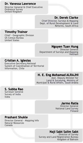
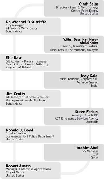
Geospatial World Forum


Prithviraj Chavan
Minister of State (Independent Charge) for Ministry of Science &
Technology & Ministry of Earth Sciences
India

Dr. F. J. Radermacher
Research Institute for Applied Knowledge Processing/n (FAW/n)
Germany


Dr. K Kasturirangan
Member Planning Commission
India

Prof.Michael Goodchild *
Professor
Univ. of California Santa Barbara
United States

K K Singh
Chairman and Managing Director
Rolta India
India

Jack Dangermond
President
ESRI
United States

Dr. K Radhakrishnan
Chairman
ISRO
India

Dr. Shailesh Nayak
Vice Secretary
Ministry of Earth Sciences
India

Steven Hagan
Vice President
Development of Technology Server, Oracle
United States

Dr. T Ramasami
Secretary
Department of Science and Technology
India

Juergen Dold
President
Geospatial Solutions Hexagon
Sweden

Jill Smith
Chief Executive Officer
DigitalGlobe
United States

Bryn A Fosburgh
Vice President
Trimble
United States

Matthew O'Connell
CEO, President and Director
GeoEye
United States

Dr. B V R Mohan Reddy
Chairman and Managing Director
Infotech Enterprises
India

Alain De Taeye
Member of Management Board
TomTom NV
The Netherlands

Prof. V S Ramamurthy
Director
National Institute of Advanced Studies
India

Jeff Jonas
Distinguished Eng. & Chief Scientist Entity
IBM
United States

Brian Bullock
President & CEO
Intermap Technologies
United States


Conference Highlights

  • NMO - Industry Exchange Forum
  • Geospatial Users Forum
  • Special Achievement Awards
  • Geospatial Excellence Awards
  • Symposia:Earth Observation Systems, Development Sector, Design and Engineering, Integrated Coastal Zone Management, GNSS
  • Seminars: Open Source Initiatives, Spatial Data Infrastructure, Utilities, Environmental Management, Cartography, Surveying and Mapping, Advancements and Trends in Photogrammetry
  • Forum: Developers Forum, Integrated Design Education Forum, Geospatial Science Forum, Geospatial Users Forum

What's in it for you

  • Get an unbiased education about emerging trends , markets, and technologies creating huge opportunities
  • Top-Level Plenary with extensive experience
  • Get the scoop on the latest products, meet with clients and drum up new business with valuable leads
  • More than 75 companies will put up exhibits at the event
  • Meet some of the best known professionals in person and exchange your experiences
  • Gain an insight into the information and learning needs that can help you tackle everyday challenges
  • Unrivalled networking opportunities
  • Knowledgeable speakers delivering critical, technical information in an understandable manner


For information related to registration contact registration@geospatialworldforum.org


For exhibition space booking, contact exhibition@geospatialworldforum.org
Principal Industry
Partner
Principal Government
Partner
Corporate Partners
Presented byStrategic PartnersAssociate Partners
Knowledge PartnersCo-Sponsors
Institutional Partners
Media Partners
You are receiving this mailer since you have attended previous GIS Development conference.To unsubscribe write us atvaishali.dixit@gisdevelopment.net
Geospatial World Forum Secretariat 
GIS Development, A-145, Sector - 63, Noida (U.P.) - 201 301
Tel: + 91 - 120 - 4612500 Fax: +91 - 120 - 4612555/666
Email: info@geospatialworldforum.org Website: geospatialworldforum.org