HUNAGI Napló legutóbbi látogatói

Címkék

#SDG11 14. ICGC 2030 Agenda 20th ISDE 3D 3D city modelling 3D city models 3D SIG 4-es metró 5. Digital Earth Summit 5. Térinformatikai Konferencia és Szakkiállítás 6th Digital Earth Summit 7 ICC&GIS adatpolitika Afrika Expo és Vásár Agenda 2030 AGEO AGILE AGILE 2014 Agile 2015 AGILE 2017 AGIT AGIT Expo Agrárinformatika Agriculture AgriFuture Appathon ARSET ASGC Atlas Human Planet 2018 Award Bernhard Harzer Verlag Best Practice BiDS 14 Big Data Big Data from Space Big Spatial Data BIM biodiversity BKK BME BME ÁGT BME VIK EIT BMWi Cadastre 2.0 CAGI cartographic heritage Cascadoss CeDEM Center for Open Data Enterprise CEODE CEOS CEOS WGISS CGS Chubu citySDK CitySmart CLGE CME CODATA conservation COP23 Copernicus Copernicus Masters Copernicus MPP CORP 2017 CORP2017 COSPAR COSPAR 2014 CSIRO Danube Data Cube Danube Participation Day of the Danube Strategy Danube Reference Data Service Infrastructure Danube_Net Data Archives Data Curation Data Documentation Initiative Data Economy data policy DCH2017 DDI DE Summit DE TGT Debrecen Debreceni Egyetem Földtudományi Intézet Defense Defense imagery Information Deqing DES 2018 DGI Digital Approaches to Cartographic Heritage Digital cartography digital cultural heritage Digital Earth Digital Earth in a Transformed Society Digital Earth Session Digital Earth Summit Digital Earth Summit 2016 Digital Earth Symposium Digital Map Heritage Digital repository Digitális Föld Digitális Föld Csúcs Digitális kulturális örökség digitális térképi örökség Disaster Disaster management Disaster Risk Disaster risk assessment DLR Doha Draught Risk Management DRDS DRDSI drones Drónok Duna Adatkocka Duna Stratégia Duna-régió Stratégia DUT e-Government e-learning courses EuroSDR EARSeL ECAI ECAI PNC ecosystems éghajlatváltozás élelmiszerbiztonság ELF ELTE ELTE IK TGT ELTE TGT ENSZ ENSZ Klíma Csúcs Environment EO EO4Alps EO4climate EO4SDG EoE EoE webinar ESA ESA ESRIN ESD ESDI-NET ESDINET ESPON Esri Esri Magyarország ESRIN Ethical reuse of data EU EU BIG IoT EU citySDK EU Data Innovation Forum EU Space Imaging EUGEO EUGEO2017 EULF EULIS EURISY EuroGeo EuroGEOSS EuroGEOSS broker EUROGI European Cohesion Policy European Lidar Mapping Forum European Space SolutionsKép: EuroSDR EuroSDR 3D EuroSDR JRC EUSDR Eye on Earth Eye on Earth Symposium Eye on Earth webinar fenntartható fejlődés FÉNY - TÉR - KÉP 2017 FÉNY-TÉR-KÉP FÉNY-TÉR-KÉP 2016 FÉNYKÉP FÉNYKÉP TÉRKÉP FET FF célok FFC FGDC FI Working Week 2017 FIG FIG Hanoi FIG Helsinki FIG Working Week FIG Working Week 2017 Föld-rendszer földhasználat földmegfigyelés földművelés földtudomány FÖMI FOSS Academy FOSS4G FOSS4G 2016 FOSS4G 2017 FOSS4G 2018 FOSS4G HU FOSS4G-Asia FOSS4G-Europe FOSS4G-HU FOSS4G.HU Foszforgézu Foszforgézúúúú Fotogrammetria Future Internet FuturICT Galway GaphiTech GCOS GDI Fórum GDI Sachsen Geiger-Mode LiDAR GEO GEO Business 2014 GEO Data and Knowledge Week GEO Data Providers Geo Delft 2018 GEO European Projects GEO Exhibit GEO Week 2017F GEO Week 2018 GEO XI Geo-ethics Geo-etika Geo-IT Geoadat GeoBIM GeoBIM Europe GeoBusiness GeoBusinessFORUM Geographic Information Science Geography of Europe Geoinformatics 2016 Geoinformatics Potsdam geoinformatika gazdaság geoinformatikai piac GeoIQ GEOMAT 2014 Geonovum Geoscience Australia Geospatial data Geospatial Intelligence Geospatial Summit Geospatial World Forum Geospatial World Forum 2016 Geospatial World Forum 2017 GEOSS GeoSUR GI EO SDG GI Forum GI Humanitarian Assistance GI services GI_Forum 2015 GI-18 GI-Forum GIM International Summit GIS GIS Open 2017 GIS Ostrava GIS Ostrava 2016 GIS-education Gisday GISopen GISopen 2016 GISopen 2017 grid computing Clouds GSDI GSTIC GWF GWF 2016 H-SPACE 2017 H2020 Health Helmholtz-Zentrum für Umweltforschung heritage management Hexagon Horizon 2020 HUNAGI HUNAGI ISPIK HUNGEO 2014 HUNSPACE HxGN HxGN 2015 ICA ICA-OSGEO ICC&GIS ICSU ICSU CODATA ICT ICT Family Farming Ideal-IST IDEAS IGARSS IGIT IGIT 2005 IJDE ILUS 2019 imaGIne 2 Indicator reporting Információs Társadalom Parlamentje information age Infotér Infotér 2014 Infoterra Innotrends 2014 Innovation INSPIRE INSPIRE 2014 INSPIRE 2015 INSPIRE 2016 INSPIRE konferencia 2016 INSPIRE validation Intelligens városok INTERGEO 2011 Intergeo 2014 INTERGEO 2015 Intergraph International Map Year Internet of Things interoperabilitás interoperability Interspect IoT IRIS ISA ISDE ISDE 9 ISDE Digital Earth European Chapter ISDE Florence ISDE10 isde7 ISDE9 ISEH ISGC 2016 ISPRS ISPRS kongresszus ISPRS Prága ISPRS XXIII Congress ITP JAXA Jövő internet JRC Kartografija.hr Kartverket Katasztrófa menedzsment képfeldolgozás Kereskedelmi lehetőségek Afrikában knowledge kockázatelemzés Kommission für Geoinformationswirtschaft KRF KU Leuven Landsat laser scanning LBS Leica Library Library Information Lidar Lidar 2014 LIDAR forestry lidar mapping Lipszy János LISC75 Living Planet Living Planet 2016 Locate17 MAGISZ Magyar Földrajzi Napok MANT Mapinfo MFGVE MFT MFTTT Mitteldeutschen GEOforum MMK-GGT mobility MTA SZTAKI MŰI Mundo GEO Museum Allience MUT Nagy Adatok NAIH NASA NASA ARC NASA World Wind népességnövekedés Next GEOSS Next GEOSS training NextGEOSS NHIT NIH NMCA NMCA Summit NMHH Norvég Alap NRC nyfsz NyME GEO Oblique Aerial Camera Systems ODC ÓE AMK OGC OGRS okos város Del Bianco CitySmart OMSZ Open data Open data business models Open Data Cube Open Geodata Open Government Data open source Open source Geospatial Open source Geospatial Education Open source Geospatial Research Open source Open data Open Standards for BIM OSGeo OSGeo Lab Budapest Ossiach Klub OSZK Paris Agreement Patrick Hogan Pitney Bowes Software Plan4all PNC 2016 Prof. Carsten Jürgens QGIS QGIS HackFest RADI Rasdaman RDA REAL CORP 2017 Recovery Regional Development remote sensing Resource Watch RESTEC Road to dignity RPAS RT&I Sächsisches GIS-Forum SAGI SAR for mapping SatCen SD SDG SDG Academy SDG National Reporting SDG reporting SDGs SDI SDI Day SEE sensor web Sentinel Sentinel-2 Smart cities Smart City smarter cities smeSpire Societal Geo-Innovation Socioeconomic potential of Land Administration Services spatial planning SPL LiDAR Strategy on SDG National Reporting STSN Sustainable City Swiss Data Cube szenzor háló Szép Magyar Térkép Szép magyar térkép 2015 Szép Magyar Térkép 2016 Tabula Hungariae társadalmasítás távérzékelés téradatok üzleti modellek térinformatika Térinformatika oktatása Térinformatikai Konferencia TÉRKÉP Térképészet térszkennelés Törökbálint Travel Award DES 2018 UAS UAV ubiquitous e-infrastructure UHI UN 2030 Agenda UN Agenda 2020 UN Climate Summit UN SDSN UN-GGIM UN-SPIDER UNIGIS Summer School University of Geneva UNOOSA UNWGIC Urban Remote Sensing Urban transitions Űripar űrkutatás VARINEX városi hősziget városiasodás várostervezés Versenyképesség VGI Wageningen WDS We Act4SDGs Webinar European Location Framework WGISS WGISS 46 Wo? kongresszus World Summit Information Society WPLA WSIS WWEC WWEC 2014 WWEC 2015 WWEC 2016 WWEC 2017 WWEC Helsinki Z_GIS

Thursday, March 31, 2011

ISPRS a térbeli adat infrastruktúráról

A WGISS csatornáján keresztűl ma érkezett hír:
'ISPRS Joint-WG Workshop on 
"Geospatial Data Infrastructure: from data acquisition and updating to smarter services"  
which will be help during 20-21 October 2011 in Guilin China . 
Detailed information can be found in http://isprs-wg41.nsdi.gov.cn/ '.
Megjegyzem, a  szervező Dr. Jiang Jie, a Nemzeti Térinformatikai Központ részéről, akivel az ISPRS SDI munkacsoportját vezettük Dr. Barsi Árpáddal egymást váltva 2004-2008 között.
Az előadásbeküldés határideje április vége.

GEO-VIII, Istanbul, Turkey, 16-17 November 2011


A GEO Titkárság mai leveléből, amely a GSDI csatornáján érkezett:
" the Eighth Plenary session of the Group on Earth Observations (GEO-VIII) will be hosted by the Scientific and Technological Research Council of Turkey (TÜBITAK) at the Istanbul Congress Center from 16 to 17 November 2011."
Magyarország a GEO tagja, a képviseletet az OMSZ elnöke látja el. 

Tuesday, March 22, 2011

2nd Geospatial Summit, Budapest 1-2 June, 2011

A szervező Fleming Europe weboldalára a címsorra klikkelve juthat.
További fontos információ linkjei:

Téradat infrastruktúra a földművelésben és környezetvédelemben


Mai postánkból: Karel Chravat meghívót küldött a Facebook-on az alábbi tartalommal. Részletekért klikk a címsorra.
“Spatial Data Infrastructure for Agriculture and Environment” workshop
12 July at 13:30
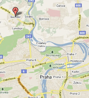
Praha Suchdol
Idézet a figyelemfelhívó közleményből:
The NaturNet Plus, SDI-EDU, EnviroGrids, Briseide and Habitats teams would like to invite you for the “Spatial Data Infrastructure for Agriculture and Environment” workshop, which will be part of EFITA/WCCA 2011http://www.efita2011.cz/. EFITA/WCCA 2011 conference is focused on Digital Agenda for 2020, ICT-technologies and knowledge management for integrated and sustainable farm management in the entire world. It is going to be held in Prague, Czech Republic, from 11th to 14th July 2011.
Purpose of the workshop
The purpose of the workshop is to present the achievements from the above mentioned projects, but also to stimulate discussion about future of SDI for agriculture and environment. Active participation during the workshop is welcomed. In case of interest of active participation, please contact Tomas Mildorf.
Contact persons: Tomas Mildorf, University of West Bohemia, mildorf(at)centrum.cz
Supposed day: Tuesday 12th July (afternoon), 2011"
Suchdol Prága egyik északi külvárosa, egyébként a Cseh Mezőgazdasági Egyetem székhelye.

Friday, March 11, 2011

15. GISopen Konferencia Székesfehérváron!

Illusztráció: képernyőrészlet a NymE GEO weboldaláról.
"Megfelelni a kihívásoknak..."
15.GIS Open Konferencia
NyME Geoinfo Kar
Székesfehérvár
2011 március 16-18
A program és egyéb információ a címsorra kattintva érhető el.

Thursday, March 10, 2011

Szakmai nap Sopronban - a StartIT felhívása


Pongrácz István a StartIT vezetője írj mai levelében:
"Szeretnélek meghívni egy soproni rendezvényre, melyet ingyenesen lehet látogatni és a Sopron Régi Informatikai Klaszter támogatásával jön létre, 2011.03.17-én.
A rendezvény témájáról, időpontjáról, helyszínéről képes kis összefoglalót érhetsz el it:
http://www.startit.hu/Letoltesek/Sopron_Intro_2011_03_17.pdf 
Ha úgy gondolod, hogy a barátaid/kollégáid körében érdekelhet valakit, vagy éppen más ér rá ellátogatni a rendezvényre, küldd tovább kérlek. Köszönöm!"

Tuesday, March 8, 2011

Március 29-én videoközvetítésen keresztül követhető lesz az ESDIN záróműhelye

Dave Lovell, az EuroGeographics ügyvezető igazgatója írta mai levelében:
"Today I have been making final preparations for the closing workshop of the eContentplus funded project ESDIN

The project has amongst other things shown that setting up an infrastructure with a significant number of distributed datasets, network services and data processing tools, all under different responsibilities and with complex specifications, is a challenging but achievable task.
The prospect of a pan-European user driven quality assured SDI is one step closer thanks to ESDIN.
I believe you will get benefit from setting aside 29th March 2011 to attend the closing workshopwhich will be webcast.
Please let us know if you will participate by registering for the workshop.

A térinformatika európai kutatóhelyeinek eredményei. Hat hét múlva lesz az idei AGILE konferencia Utrechtben.


Mai postánkból. Ludo Engelen a Leuveni Katolikus Egyetem Térbeli alkalmazások részlegétől továbbította az AGILE 2011 figyelemfelhívó levelét:
"Dear colleague,
Within 6 weeks from now, the AGILE 2011 conference will take place. From April 18-21 you are welcome in Utrecht, the Netherlands. An interesting programme will be offered, thanks to 26 full papers, 40 short papers, 23 posters together with three key note presentations. On Monday April 18, 8 workshops will take place, so without any doubt there is workshop in your area of interest .
Of course, we offer also the usual social events, like the icebreaker in the medieval downtown of Utrecht, a choice of activities on Tuesday evening like a run, a walk in historical downtown Utrecht,  and a visit to one of the largest collections of old maps at the University library, and the  conference dinner on Wednesday evening.
A new activity is the PhD- evening on Tuesday evening to be organized by a group of PhD students from Utrecht University and offered by the local committee.
Please check the website ( www.uu.nl/geo/agile2011) for all these events and the latest updates.
Do not forget to register. The deadline for the reduced fee is March 14th. We hope to have a draft programme ready by that date as well.
As hotel accommodation might become a problem, we advise you to book your hotel as soon as possible. 
Looking forward to meet you in Utrecht,
Fred Toppen (local committee)
Stan Geertman (programme committee)"

Előadásfelhívás a Helyfüggő szolgáltatások (LBS) 8. Szimpóziumára

Mai postánkból: Zentai László professzor (ELTE TGT), az ICA Magyar Nemzeti Bizottság elnöke hívja fel olvasóink figyelmét Prof.Dr.Georg Gartner ICA alelnök levelének közreadásábval a címbeli rendezvényre:


8th Symposium on LBS - Call for Paper

"Dear Colleague,
the 8th Symposium on Location-based Services will take place at the Vienna University of Technology in Vienna, Austria, from 21-23 November 2011.
Please find the Call for Paper attached. Please notice, that we offer three different streams of contributions, full papers, extended abstracts  and showcases.
I would be pleased, if you consider active participation to that exciting event and if you could forward further the Call for Paper to those colleagues being interested in this topic as well.
Sorry for ev. cross posting.
Kind regards from Vienna,
Georg Gartner
--
Univ.Prof.Mag.Dr. Georg Gartner
Research Group Cartography
Department of Geoinformation and Cartography
Vienna University of Technology
Erzherzog-Johann-Platz 1/127-2
http://cartography.tuwien.ac.at
International Cartographic Association
Vice-President
http://www.icaci.org"

Monday, March 7, 2011

Jog a digitális környezetben - Tudományos konferencia Moszkvában


Mai postánkból. Prof. Paul F. Uhlir az amerikai Nemzeti Tudományos Akadémia Nemzeti Kutatásu Tanács Kutatási Adatok és Innformáció Testületének NRC Board on Research Data and Information
National Academy of Sciences igazgatója írja a GSDI Legal & SocioEcon bizottságban: 


International Conference  "Law in Digital Environment".
April, 21-22, Moscow, National Research University "Higher School of Economics"
            April, 21
            9.30-10.00 - Registration
           10.00-11.30 - Plenary Meeting "Transparency and Liability"
           11.30-12.00 - Coffee-break
           12.00-14.00 - Plenary Meeting "Transparency and Liability"
          15.00-17.00 - Panel 1 "Copyright in Digital Era: comparative aspects"
                                 Panel 2 "Information Security and Protection of Personal Data"
April, 22
10.00- 13.30 - Panel 1 "Copyright in Digital Era: comparative aspects"
                        Panel 2 " Access to Public Information"
15.00-17.00 - Plenary Meeting "Law in Digital Environment"
Bővebb információ: Prof. Irina Bogdanovskaia  bogdanovskaia@yahoo.com.

Friday, March 4, 2011

Március 7-ig még lehet jelentkezni előadással az ISDE-7 szimpóziumra


A Digitális Föld Nemzetközi Társaság titkárságáról ma arról érkezett hír, hogy egy héttel meghosszabbították az augusztusi ISDE-7 rendezvényre előadással való bejelentkezés határidjét.
"You are cordially invited to attend the 7th International Symposium on Digital Earth (ISDE7), which will be held in Perth, Australia, from 23-25 August 2011.
Digital Earth is a global initiative as virtual representation of the planet. It is a comprehensive production of Earth Science, Spatial Science and Information Science, to monitor and forecast nature and human behavior. Nowadays, digital earth has been vigorously developed, and its influence on our daily life has well been demonstrated via internet. The 7th ISDE will play a crucial role in reviewing the achievement and discussing the future development of digital earth.
Abstract submission was due on 28 February. The Local Organizing Committee of the Confence has decided to extend the deadline to March 7If you are interested in presenting at ISDE7, please submit abstracts,please visit http://www.isde7.net/call-for-papers/Abstracts.html.
Should you have any questions about the conference, please contact the conference secretariat at isde7@iceaustralia.com or email walis@walis.wa.gov.au,or contact the WALIS Office on +61 8 9273 7046. We look forward to seeing you in Perth."

Secretariat, International Society for Digital Earth
Tel:  +86-10-82178912 Fax: +86-10-82178916
Add: No.9 Dengzhuang South Road, Haidian District,
       Beijing 100094, China